

Björkdal – Near Mine Exploration Update
PERTH, Australia, July 08, 2026 (GLOBE NEWSWIRE) -- Alkane Resources Limited (ASX: ALK; TSX: ALK; OTCQX: ALKRY) ("Alkane" or "the Company") is pleased to report further positive results from extension and infill drilling at the Björkdal Gold Mine in Sweden.
Program Summary
- An additional 29 drill holes have been completed targeting the Eastern and Northern extensions of the Björkdal mine since Alkane's previous release (ASX announcement 15 October 2025 titled ‘Björkdal Resources and Reserves Statement FY25’)
- The new drilling, completed in rolling phases of extension and infill across both target areas, has significantly enhanced confidence in the understanding of vein geometry and grade-controlling structures.
- Grade continuity within both areas has been supported by the drilling with high-grade intercepts within the eastern extension extending the known mineralisation to a depth of 762 m below surface which is the deepest yet recorded in the field.
- Current and planned exploration drilling will continue to target along-strike and down-dip extensions of the known mineralisation, with the objective of further expanding mineral resources and supporting future mine-life growth.
Assay Highlights
-
Eastern Extension
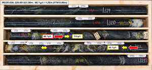
- 86.1 g/t gold over 1.25 m (ETW 0.80 m) in MU25-030
- 81.3 g/t gold over 4.40 m (ETW 2.20 m) in MU25-022
- 78.3 g/t gold over 0.30 m (ETW 0.21 m) in MU26-005
-
39.3 g/t gold over 0.50 m (ETW 0.41 m) in MU25-011
-
Northen Extension
- 31.5 g/t gold over 0.85 m (ETW 0.22 m) in MU26-002
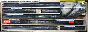
- 25.2 g/t gold over 0.60 m (ETW 0.42 m) in MU25-027
- 17.1 g/t gold over 0.80 m (ETW 0.40 m) in MU25-016
-
15.4 g/t gold over 4.00 m (ETW 1.37 m) in MU25-032
Alkane Managing Director & CEO, Nic Earner, said:
“We are encouraged by the results coming from our near mine extension programs at Björkdal. The positive results indicate that the mineral system is still strong and open at depth. These results, together with the new resource at Storheden, support our confidence in the potential to increase production in addition to the longevity of the operation.”
Björkdal Gold Mine
Alkane Resources Ltd 100%
The Björkdal Gold Mine is located on the eastern margin of the prolific Skellefte Belt in northern Sweden, approximately 28 km northwest of Skellefteå and 750 km north of Stockholm (Figure 1).
The deposit was discovered in 1983 by Terra Mining AB through a glacial till sampling program that identified anomalous gold values. Follow-up exploration led to the discovery of gold mineralisation in bedrock in 1985, with resource definition drilling commencing in 1986. Concurrent metallurgical test work and feasibility studies delivered positive results, paving the way for the commencement of mining operations in July 1988.
Since production began, Björkdal has undergone several changes in ownership while continuing to operate as a significant gold-producing asset. Most recently, the operation became wholly owned by Alkane Resources following its merger with Mandalay Resources in August 2025.
Production is supported by the 1.4 Mtpa processing plant, which has been progressively upgraded since commissioning. Current ore feed is sourced from underground mining operations and surface low-grade stockpiles.
Since the start of production in 1988, the Björkdal Mine has produced approximately 1.69 million ounces of gold. Continued exploration success has delivered growth in both Mineral Resources and Ore Reserves, with the current Ore Reserve reported, as of 30 June 2025, of 13.05 Mt grading 1.29g/t gold (ASX announcement 15 October 2025 titled ‘Björkdal Resources and Reserves Statement FY25’)
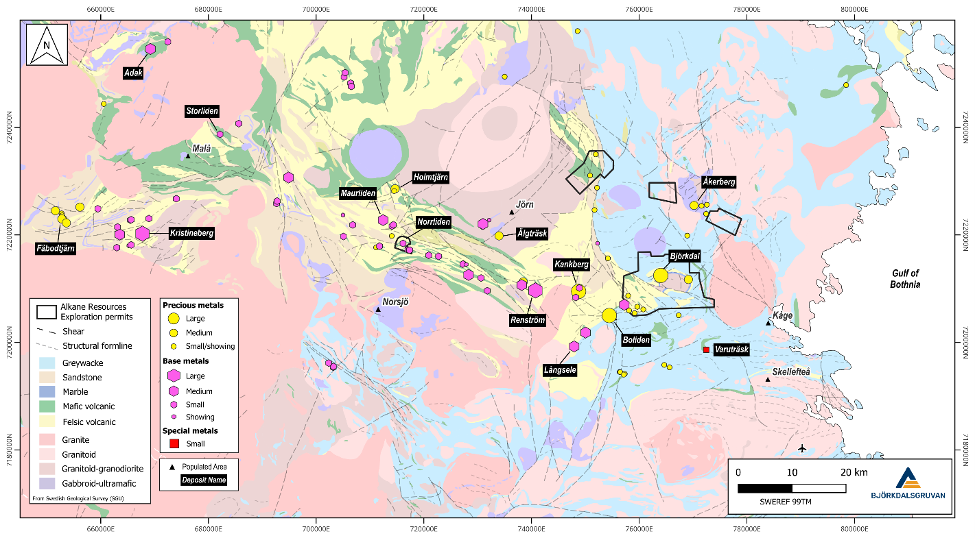
Figure 1: Regional map showing the location of Björkdalsgruvan relative to the broader Skellefte Belt, highlighting known base and precious metal occurrences (SWEREF 99TM).
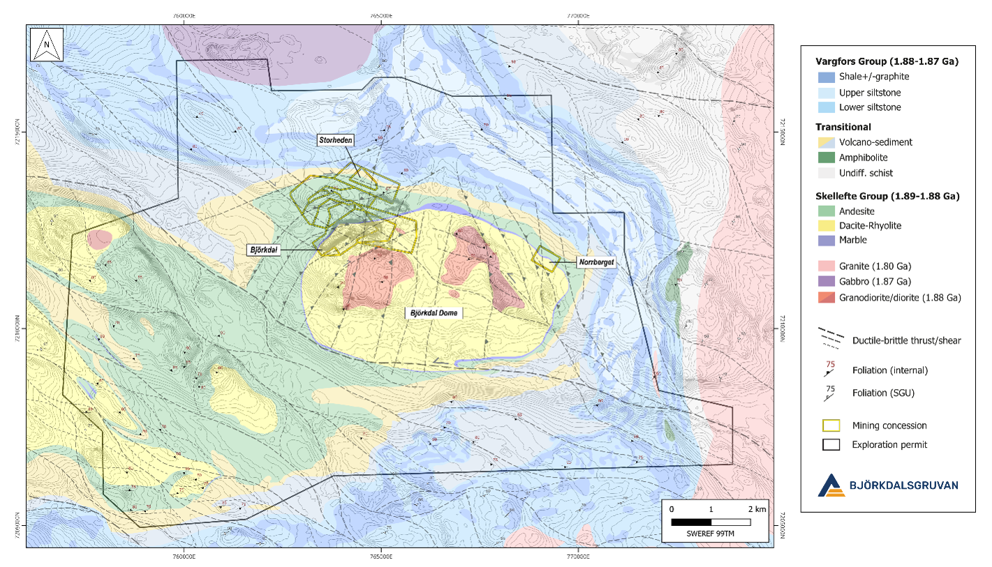
Figure 2: Regional geological map showing the locations of the three main deposits in the Björkdal area and contiguous exploration permits (SWEREF 99TM).
Deposit Geology
The Björkdal Gold Mine is located in the eastern part of the Paleoproterozoic Skellefte District in northern Sweden. The Skellefte District constitutes a 1.89–1.88 Ga volcanic arc and hosts numerous volcanic massive sulphide (VMS) and lode gold deposits (Figure 1).
Mineralisation at Björkdal occurs primarily as free milling gold and is hosted within centimetre- to meter-wide, subvertical quartz veins, predominantly beneath a marble horizon within a complex sequence of volcano-sedimentary rocks belonging to the Upper and Lower Skellefte Groups (Figure 2). The mineralised system plunges eastward and northward (mine grid), forming a 30–60 metre thick zone of sheeted quartz veins containing gold mineralisation (Figure 4).
The principal vein set strikes east-west (070–090° in mine grid coordinates) and represents the primary target for underground mining both above and below the marble horizon. Additional subordinate vein sets occur at varying orientations and may also host economically significant gold mineralisation.
Vein geometry and distribution are strongly influenced by shearing, thrusting and folding. Variations in vein orientation (Figure 3), mineralogy, wall-rock alteration and fluid inclusion characteristics indicate multiple phases of veining and mineralising fluid activity.
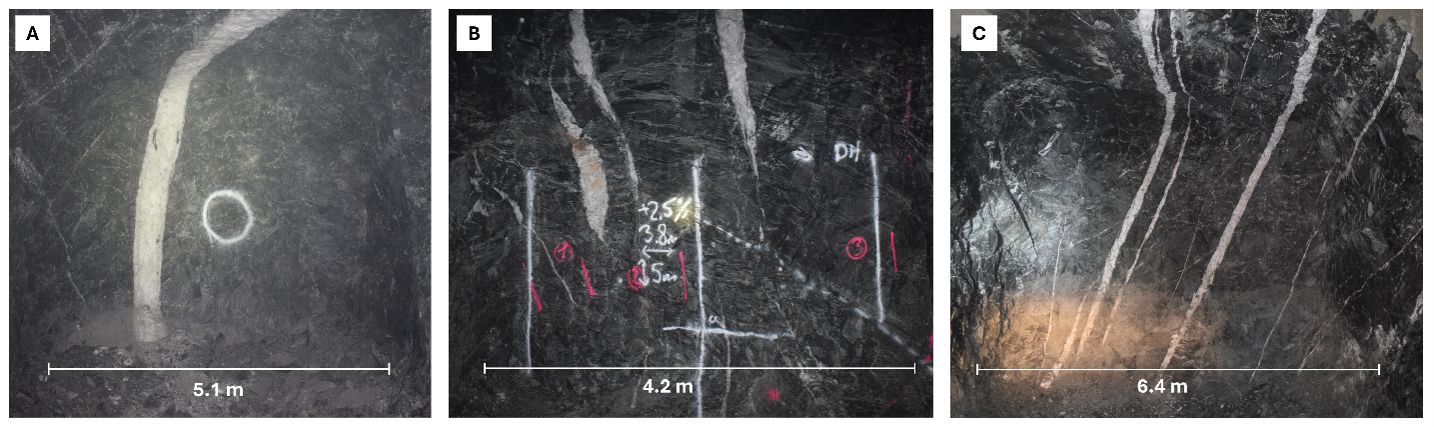
Figure 3: Typical auriferous quartz veining observed at Björkdal. (A) Main Zone. (B) Lake Zone. (C) Lake Zone Above.
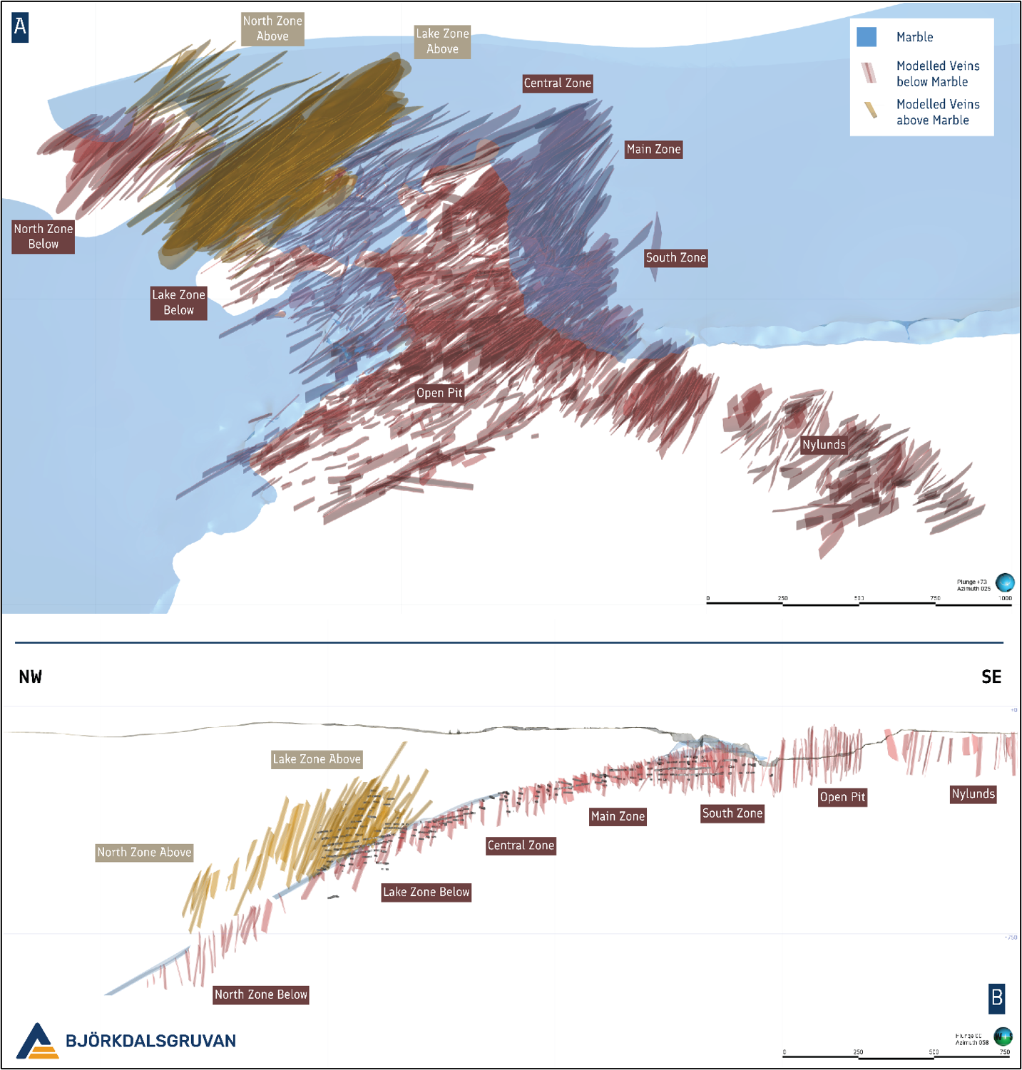
Figure 4: (A) Oblique view looking down and to the NE (Mine Grid) displaying known auriferous quartz veining at Björkdal. (B) Cross section ± 30 metres along the Björkdal deposit looking to the NE (Mine Grid).
Drilling Results
Since the previous release, 29 growth and infill drill holes have been completed, totalling 15,568m of diamond drilling. Drilling was focused on two target areas within the underground mine, the Eastern and Northern Extension (Figure 5). Both target areas are situated stratigraphically below the marble unit that extends throughout the mine area.
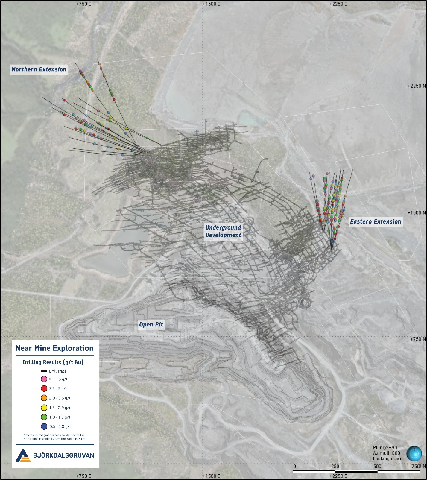
Figure 5: Mine Scale overview showing the location of the most recent drilling in relation to current underground development (Mine Grid).
Eastern Extension
Thirteen holes have been drilled along the eastern flank of the mine since June 2025, totalling 6,304 m with an average hole depth of 485 m. The program was completed in two phases of infill and extensional drilling, targeting strike and depth extensions of veining within the Main Zone of the underground mine. A total of 169 ore-grade intercepts have been identified within the target zone, including the best result from drillhole MU25-030, which returned 86.1 g/t gold over 1.25 m (ETW 0.80 m). The program also delivered the deepest intercept recorded at the mine to date, with drillhole MU25-021 returning 3.5 g/t gold over 3.20 m (ETW 2.45 m) at -976 RL (-762 m elevation) (Figure 6).
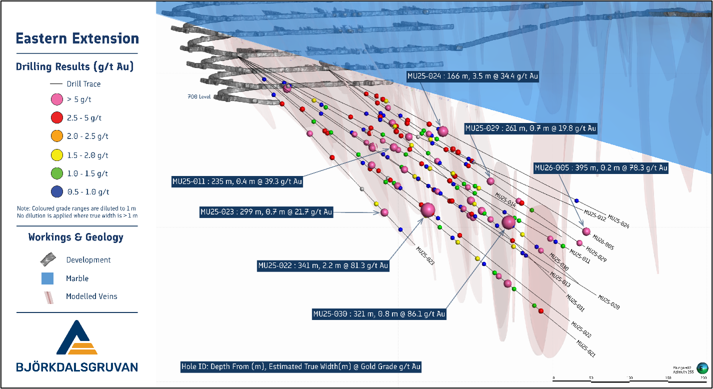
Figure 6: Oblique view to the WSW highlighting results from the most recent drilling campaign along the eastern flank of the underground mine.
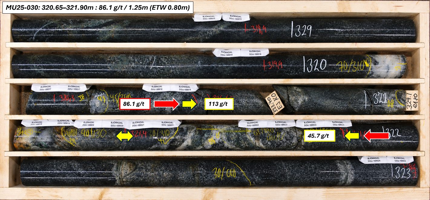
Figure 7: Core tray photograph from MU25-030, where the highest-grade interval of the drill program was intersected.
Northern Extension
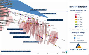
Sixteen holes were drilled within the Northern Extension of the underground mine since June 2025, totalling 9,264 m, with an average hole depth of 580 m. Building on the success of previous drilling campaigns, the program was designed to improve the understanding of vein morphology and structural controls on mineralisation, while testing the northern and western extensions of known veining.
The program successfully confirmed previously identified vein swarms and further enhanced confidence in the geological interpretation of the area. Assessment of the western extent of the target zone was constrained by the availability of underground drill platforms; however, the information collected has enabled the development of a more robust structural model, which will support future targeting and resource growth within the Northern Extension. A total of 68 ore-grade intercepts have been identified within the target zone, including the best result from drillhole MU26-002, which returned 31.5 g/t gold over 0.85 m (ETW 0.22 m). Drilling has confirmed mineralised veins up to approximately 600 m from existing underground development (Figure 8).
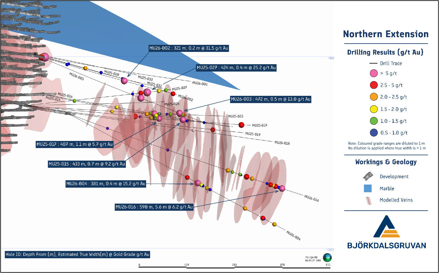
Figure 8: Oblique view to the SW highlighting results from the most recent drilling campaign in the Northern extension of the underground mine.
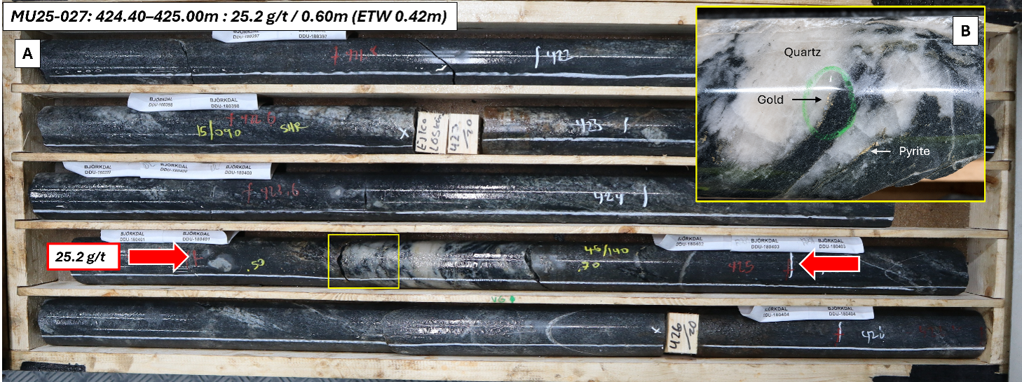
Figure 9: Drill core photos from MU25-027 showing an intercept grading 25.2 g/t gold over 0.60 m (ETW 0.42 m) (A) and a close-up of mineralised quartz vein (B).
Future Plans
Mineralisation remains open at depth and along strike in both the Northern Extension and Eastern Extension target areas. In FY27, underground drilling will continue in staged programs of infill and extension drilling aimed at improving geological confidence and testing continuity of mineralisation.
At the Northern Extension, drilling will continue to test both depth and along-strike continuity, with western extension drilling to be supported by the establishment of a dedicated underground drill platform. This will enable improved drill orientations and reduce scheduling conflicts between drilling and mining activities.
At the Eastern Extension, mineralisation remains open at depth and along strike to the east. Future drilling will focus on step-out extensional testing to assess the continuity of known vein swarms and refine the structural controls on mineralisation in this area.
This document has been authorised for release to the market by Nic Earner, Managing Director and CEO.
ABOUT ALKANE ‐ www.alkres.com ‐ ASX:ALK | TSX: ALK | OTCQX: ALKRY
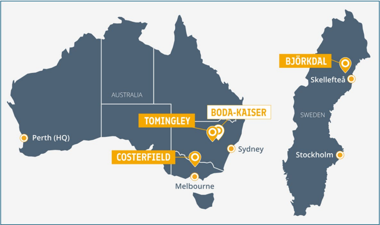
Alkane (ASX:ALK; TSX:ALK; OTCQX:ALKEF) is an Australia-based gold and antimony producer with a portfolio of three operating mines across Australia and Sweden. The Company has a strong balance sheet and is positioned for further growth.
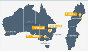
Alkane’s wholly owned producing assets are the Tomingley open pit and underground gold mine southwest of Dubbo in Central West New South Wales, the Costerfield gold and antimony underground mining operation northeast of Heathcote in Central Victoria, and the Björkdal underground gold mine northwest of Skellefteå in Sweden (approximately 750 km north of Stockholm). Ongoing near-mine regional exploration continues to grow resources at all three operations.
Alkane also owns the very large gold-copper porphyry Boda-Kaiser Project in Central West New South Wales and has outlined an economic development pathway in a Scoping Study. The Company has ongoing exploration within the surrounding Northern Molong Porphyry Project and is confident of further enhancing eastern Australia’s reputation as a significant gold, copper and antimony production region.
Competent / Qualified Persons Statement
Certain information in this announcement relating to Exploration Results has been previously released to the ASX. Alkane confirms that it is not aware of any new information or data that materially affects the information included in those market announcements and that all material assumptions and technical parameters underpinning the estimates and Exploration Results in those announcements continue to apply and have not materially changed.
The information in this report that relates to the Costerfield Exploration Results is based on, and fairly represents, information compiled and verified by Mr Chris Davis. Mr Davis is a Chartered Professional (Geology) of the Australasian Institute of Mining and Metallurgy (MAusIMM CP(Geo)) and a Member of the Australian Institute of Geoscientists (MAIG).
Mr Davis has sufficient experience that is relevant to the style of mineralisation and type of deposit under consideration and to the activity being undertaken to qualify as a Competent Person as defined in the 2012 Edition of the “Australian Code for Reporting of Exploration Results, Mineral Resources, and Ore Reserves” (JORC Code).
For the purposes of National Instrument 43-101 – Standards of Disclosure for Mineral Projects (‘NI 43-101’), the scientific and technical information contained in this announcement relating to the Costerfield Exploration Results has been prepared under the supervision of, and approved by, Mr Chris Davis, who is a “qualified person” as defined in NI 43-101. Mr Davis is employed by Alkane as Chief Geologist and, as an employee of Alkane, is not considered independent of Alkane within the meaning of NI 43-101.
Mr Davis consents to the inclusion in this report of the matters based on his information in the form and context in which they appear.
Cautionary Note Regarding Forward-Looking Information and Statements
This announcement contains certain forward-looking information and forward-looking statements within the meaning of applicable securities legislation and may include future-oriented financial information or financial outlook information (collectively Forward-Looking Information). Actual results and outcomes may vary materially from the amounts set out in any Forward-Looking Information. As well, Forward-Looking Information may relate to: future outlook and anticipated events; expectations regarding exploration potential; production capabilities and future financial or operating performance, including AISC, investment returns, margins and share price performance; production and cost guidance and the timing thereof; issuing updated resources and reserves estimate and the timing thereof; the potential of Alkane to meet industry targets, public profile and expectations; and future plans, projections, objectives, estimates and forecasts and the timing related thereto.
Forward-Looking Information is generally identified by the use of words like "will", "create", "enhance", "improve", "potential", "expect", "upside", "growth" and similar expressions and phrases or statements that certain actions, events or results "may", "could", or "should", or the negative connotation of such terms, are intended to identify Forward-Looking Information.
Although Alkane believes that the expectations reflected in the Forward-Looking Information are reasonable, undue reliance should not be placed on Forward-Looking Information since no assurance can be provided that such expectations will prove to be correct. Forward-Looking Information is based on information available at the time those statements are made and/or good faith belief of the officers and directors of Alkane as of that time with respect to future events and are subject to risks and uncertainties that could cause actual results to differ materially from those expressed in or suggested by the Forward-Looking Information. Forward-Looking Information involves numerous risks and uncertainties. Such factors include, without limitation: risks relating to changes in the gold and antimony price.
Forward-Looking Information is designed to help readers understand Alkane’s views as of that time with respect to future events and speak only as of the date they are made. Except as required by applicable law, Alkane assumes no obligation to update or to publicly announce the results of any change to any forward-looking statement contained or incorporated by reference herein to reflect actual results, future events or developments, changes in assumptions or changes in other factors affecting the Forward-looking Information. If Alkane updates any one or more forward-looking statements, no inference should be drawn that the company will make additional updates with respect to those or other Forward-looking Information. All Forward-Looking Information contained in this announcement is expressly qualified in its entirety by this cautionary statement.
Disclaimer
Alkane has prepared this announcement based on information available to it. No representation or warranty, express or implied, is made as to the fairness, accuracy, completeness or correctness of the information, opinions or conclusions contained in this announcement. To the maximum extent permitted by law, none of Alkane, its directors, officers, employees, associates, advisers and agents, nor any other person accepts any liability, including, without limitation, any liability arising from fault or negligence on the part of any of them or any other person, for any loss arising from the use of this announcement or its contents or otherwise arising in connection with it.
This announcement is not an offer, invitation, solicitation, or other recommendation with respect to the subscription for, purchase or sale of any security, and neither this announcement nor anything in it shall form the basis of any contract or commitment whatsoever.
APPENDIX 1 – Tabulated Drilling Results
Significant intercepts from Near Mine Exploration drilling program at Björkdal
| Hole ID | From (m) | To (m) | Interval | Estimated True Width (m) | Gold Grade (g/t) | Gold Grade diluted to 1 m (g/t) |
| MU25-011 | 69 | 70 | 1.00 | 0.94 | 1.03 | 0.97 |
| MU25-011 | 77 | 78 | 1.00 | 0.82 | 0.88 | 0.72 |
| MU25-011 | 114 | 115 | 1.00 | 0.71 | 2.32 | 1.64 |
| MU25-011 | 125.3 | 126 | 0.70 | 0.54 | 1.22 | 0.65 |
| MU25-011 | 131.8 | 132.7 | 0.90 | 0.69 | 1.93 | 1.33 |
| MU25-011 | 189 | 190 | 1.00 | 0.64 | 0.84 | 0.54 |
| MU25-011 | 193.3 | 194.4 | 1.10 | 0.38 | 1.34 | 0.50 |
| MU25-011 | 198.2 | 199.4 | 1.20 | 0.21 | 22.40 | 4.67 |
| MU25-011 | 218 | 218.9 | 0.90 | 0.74 | 6.80 | 5.01 |
| MU25-011 | 235 | 235.5 | 0.50 | 0.41 | 39.30 | 16.10 |
| MU25-011 | 241.2 | 242.4 | 1.20 | 0.98 | 7.08 | 6.96 |
| MU25-011 | 252.8 | 254 | 1.20 | 1.04 | 1.05 | 1.05 |
| MU25-011 | 277 | 278 | 1.00 | 0.71 | 3.75 | 2.65 |
| MU25-011 | 284.3 | 285 | 0.70 | 0.66 | 1.30 | 0.86 |
| MU25-011 | 289 | 290.7 | 1.70 | 1.54 | 1.89 | 1.89 |
| MU25-011 | 403 | 404 | 1.00 | 0.34 | 1.86 | 0.64 |
| MU25-011 | 418 | 419 | 1.00 | 0.87 | 1.23 | 1.07 |
| MU25-011 | 425 | 426 | 1.00 | 0.64 | 2.00 | 1.29 |
| MU25-011 | 472 | 474 | 2.00 | 1.29 | 6.52 | 6.52 |
| MU25-011 | 481 | 481.5 | 0.50 | 0.43 | 1.98 | 0.86 |
| MU25-011 | 492 | 493 | 1.00 | 0.87 | 1.73 | 1.50 |
| MU25-012 | 184 | 185 | 1.00 | 0.87 | 0.87 | 0.75 |
| MU25-012 | 204 | 205 | 1.00 | 0.77 | 0.89 | 0.68 |
| MU25-012 | 225.15 | 226.1 | 0.95 | 0.54 | 3.11 | 1.69 |
| MU25-012 | 280 | 280.65 | 0.65 | 0.50 | 1.40 | 0.70 |
| MU25-012 | 300 | 300.8 | 0.80 | 0.57 | 5.04 | 2.85 |
| MU25-013 | 77 | 78 | 1.00 | 0.77 | 23.40 | 17.93 |
| MU25-013 | 181.2 | 182.15 | 0.95 | 0.61 | 0.90 | 0.55 |
| MU25-013 | 185.4 | 186 | 0.60 | 0.46 | 14.90 | 6.85 |
| MU25-013 | 204.9 | 205.4 | 0.50 | 0.38 | 14.30 | 5.48 |
| MU25-013 | 215.5 | 216.2 | 0.70 | 0.61 | 37.20 | 22.55 |
| MU25-013 | 232.1 | 232.8 | 0.70 | 0.61 | 1.37 | 0.83 |
| MU25-013 | 239 | 240 | 1.00 | 0.26 | 2.12 | 0.55 |
| MU25-013 | 262.2 | 263.3 | 1.10 | 0.95 | 1.18 | 1.12 |
| MU25-013 | 289 | 291.9 | 2.90 | 2.22 | 1.96 | 1.96 |
| MU25-013 | 306.6 | 307.3 | 0.70 | 0.54 | 1.12 | 0.60 |
| MU25-013 | 314.5 | 317.7 | 3.20 | 2.45 | 2.87 | 2.87 |
| MU25-013 | 341.8 | 343 | 1.20 | 0.85 | 2.91 | 2.47 |
| MU25-013 | 363.4 | 364.1 | 0.70 | 0.45 | 1.62 | 0.73 |
| MU25-013 | 375.3 | 376.7 | 1.40 | 1.07 | 8.76 | 8.76 |
| MU25-013 | 381 | 382 | 1.00 | 0.87 | 9.84 | 8.52 |
| MU25-013 | 449 | 450 | 1.00 | 0.64 | 2.76 | 1.77 |
| MU25-013 | 464 | 465.7 | 1.70 | 0.58 | 1.14 | 0.66 |
| MU25-013 | 470 | 471 | 1.00 | 0.50 | 1.25 | 0.63 |
| MU25-014 | 169.5 | 170.2 | 0.70 | 0.54 | 4.89 | 2.62 |
| MU25-014 | 200.5 | 201.15 | 0.65 | 0.63 | 4.82 | 3.03 |
| MU25-014 | 218.9 | 219.6 | 0.70 | 0.54 | 1.99 | 1.07 |
| MU25-014 | 257.6 | 263.7 | 6.10 | 5.73 | 2.20 | 2.20 |
| MU25-014 | 327.4 | 328 | 0.60 | 0.46 | 4.35 | 2.00 |
| MU25-014 | 361.7 | 362.95 | 1.25 | 1.02 | 1.34 | 1.34 |
| MU25-014 | 364.8 | 371.6 | 6.80 | 6.39 | 1.70 | 1.70 |
| MU25-015 | 99.5 | 100.1 | 0.60 | 0.25 | 5.92 | 1.50 |
| MU25-015 | 323.6 | 325.4 | 1.80 | 0.90 | 2.47 | 2.22 |
| MU25-015 | 352.15 | 352.8 | 0.65 | 0.22 | 8.66 | 1.93 |
| MU25-015 | 432.65 | 433.5 | 0.85 | 0.65 | 9.21 | 6.00 |
| MU25-016 | 237 | 238 | 1.00 | 0.77 | 2.08 | 1.59 |
| MU25-016 | 345.1 | 345.6 | 0.50 | 0.25 | 4.73 | 1.18 |
| MU25-016 | 357.4 | 358.2 | 0.80 | 0.40 | 17.10 | 6.84 |
| MU25-017 | 335.1 | 335.8 | 0.70 | 0.45 | 11.10 | 4.99 |
| MU25-017 | 350.7 | 351.5 | 0.80 | 0.66 | 0.93 | 0.61 |
| MU25-017 | 383.5 | 384.5 | 1.00 | 0.87 | 2.16 | 1.87 |
| MU25-017 | 385.5 | 386.3 | 0.80 | 0.69 | 1.45 | 1.00 |
| MU25-017 | 389.8 | 390.6 | 0.80 | 0.61 | 1.63 | 1.00 |
| MU25-017 | 394.5 | 395.8 | 1.30 | 1.13 | 1.38 | 1.38 |
| MU25-017 | 401.9 | 402.9 | 1.00 | 0.64 | 2.24 | 1.44 |
| MU25-017 | 406.9 | 408.5 | 1.60 | 1.13 | 5.71 | 5.71 |
| MU25-017 | 490 | 490.5 | 0.50 | 0.38 | 1.91 | 0.73 |
| MU25-017 | 647.2 | 647.7 | 0.50 | 0.35 | 13.20 | 4.67 |
| MU25-019 | 609.2 | 611 | 1.80 | 1.16 | 2.82 | 2.82 |
| MU25-020 | 135.8 | 136.8 | 1.00 | 0.71 | 0.92 | 0.65 |
| MU25-020 | 219.65 | 220.05 | 0.40 | 0.31 | 32.50 | 9.96 |
| MU25-020 | 271.6 | 272.6 | 1.00 | 0.71 | 17.30 | 12.23 |
| MU25-020 | 288.4 | 289.2 | 0.80 | 0.51 | 3.26 | 1.68 |
| MU25-020 | 294.1 | 294.6 | 0.50 | 0.45 | 1.82 | 0.82 |
| MU25-020 | 321.2 | 321.7 | 0.50 | 0.38 | 1.53 | 0.59 |
| MU25-020 | 325.5 | 326.35 | 0.85 | 0.55 | 12.40 | 6.77 |
| MU25-020 | 330.2 | 331.25 | 1.05 | 0.60 | 1.51 | 0.91 |
| MU25-020 | 349 | 350 | 1.00 | 0.57 | 6.63 | 3.80 |
| MU25-020 | 363.45 | 363.95 | 0.50 | 0.43 | 1.37 | 0.59 |
| MU25-020 | 365.9 | 371.4 | 5.50 | 3.89 | 6.65 | 6.65 |
| MU25-020 | 381.2 | 382.2 | 1.00 | 0.82 | 2.84 | 2.33 |
| MU25-020 | 387.1 | 388 | 0.90 | 0.78 | 0.81 | 0.63 |
| MU25-021 | 47.3 | 47.95 | 0.65 | 0.33 | 2.08 | 0.68 |
| MU25-021 | 135.1 | 135.85 | 0.75 | 0.26 | 5.09 | 1.31 |
| MU25-021 | 154.3 | 155.85 | 1.55 | 1.00 | 2.76 | 2.75 |
| MU25-021 | 159.25 | 160.2 | 0.95 | 0.73 | 2.85 | 2.07 |
| MU25-021 | 222 | 222.8 | 0.80 | 0.61 | 1.16 | 0.71 |
| MU25-021 | 234.7 | 235.7 | 1.00 | 0.50 | 4.01 | 2.01 |
| MU25-021 | 262 | 263.2 | 1.20 | 0.51 | 2.74 | 1.39 |
| MU25-021 | 332.3 | 335.5 | 3.20 | 1.60 | 1.64 | 1.64 |
| MU25-021 | 358 | 358.8 | 0.80 | 0.69 | 1.55 | 1.07 |
| MU25-021 | 380.4 | 381.4 | 1.00 | 0.87 | 1.04 | 0.90 |
| MU25-021 | 390 | 390.8 | 0.80 | 0.51 | 3.02 | 1.55 |
| MU25-021 | 424.7 | 425.7 | 1.00 | 0.87 | 2.29 | 1.98 |
| MU25-021 | 436.2 | 437.4 | 1.20 | 0.60 | 1.00 | 0.60 |
| MU25-021 | 454.85 | 456.4 | 1.55 | 1.00 | 1.41 | 1.41 |
| MU25-021 | 462.45 | 463.35 | 0.90 | 0.69 | 9.88 | 6.81 |
| MU25-021 | 478.5 | 479.1 | 0.60 | 0.46 | 35.00 | 16.09 |
| MU25-021 | 489.9 | 490.6 | 0.70 | 0.54 | 2.49 | 1.34 |
| MU25-021 | 525.5 | 526.7 | 1.20 | 0.77 | 1.53 | 1.18 |
| MU25-021 | 536.2 | 539.4 | 3.20 | 2.45 | 3.52 | 3.52 |
| MU25-022 | 116.6 | 116.95 | 0.35 | 0.20 | 19.30 | 3.87 |
| MU25-022 | 167.65 | 169.6 | 1.95 | 0.97 | 1.14 | 1.11 |
| MU25-022 | 217.9 | 218.45 | 0.55 | 0.39 | 3.73 | 1.45 |
| MU25-022 | 241.2 | 242.95 | 1.75 | 1.24 | 13.53 | 13.53 |
| MU25-022 | 253.75 | 255.3 | 1.55 | 1.00 | 2.25 | 2.24 |
| MU25-022 | 274.15 | 277.1 | 2.95 | 1.48 | 2.79 | 2.79 |
| MU25-022 | 281.95 | 283.05 | 1.10 | 0.95 | 1.32 | 1.26 |
| MU25-022 | 288.2 | 289.2 | 1.00 | 0.64 | 17.29 | 11.12 |
| MU25-022 | 293.3 | 294 | 0.70 | 0.61 | 1.37 | 0.83 |
| MU25-022 | 331.05 | 332.2 | 1.15 | 1.00 | 2.91 | 2.90 |
| MU25-022 | 341.2 | 345.6 | 4.40 | 2.20 | 81.31 | 81.31 |
| MU25-022 | 349.7 | 351.5 | 1.80 | 1.38 | 2.46 | 2.46 |
| MU25-022 | 361.3 | 362 | 0.70 | 0.61 | 1.35 | 0.82 |
| MU25-022 | 400.5 | 400.95 | 0.45 | 0.29 | 7.62 | 2.20 |
| MU25-023 | 72.9 | 73.85 | 0.95 | 0.61 | 1.47 | 0.90 |
| MU25-023 | 90 | 91.05 | 1.05 | 0.80 | 3.35 | 2.69 |
| MU25-023 | 147.15 | 147.7 | 0.55 | 0.35 | 20.80 | 7.35 |
| MU25-023 | 193.1 | 193.6 | 0.50 | 0.21 | 14.80 | 3.13 |
| MU25-023 | 281.2 | 284.4 | 3.20 | 2.06 | 1.93 | 1.93 |
| MU25-023 | 299 | 300.05 | 1.05 | 0.67 | 21.70 | 14.65 |
| MU25-023 | 332.2 | 333 | 0.80 | 0.51 | 1.78 | 0.92 |
| MU25-024 | 69.7 | 72.1 | 2.40 | 1.20 | 3.12 | 3.12 |
| MU25-024 | 79.4 | 80.3 | 0.90 | 0.69 | 4.36 | 3.00 |
| MU25-024 | 84.05 | 85.1 | 1.05 | 0.52 | 3.09 | 1.62 |
| MU25-024 | 147.5 | 148.5 | 1.00 | 0.87 | 4.33 | 3.75 |
| MU25-024 | 161.5 | 162 | 0.50 | 0.32 | 2.35 | 0.76 |
| MU25-024 | 166 | 170.3 | 4.30 | 3.52 | 34.37 | 34.37 |
| MU25-024 | 363.5 | 363.9 | 0.40 | 0.35 | 2.03 | 0.70 |
| MU25-025 | 283.5 | 284.5 | 1.00 | 0.57 | 2.69 | 1.54 |
| MU25-025 | 434 | 434.6 | 0.60 | 0.56 | 1.85 | 1.04 |
| MU25-025 | 435.5 | 436.4 | 0.90 | 0.69 | 1.17 | 0.81 |
| MU25-025 | 458.2 | 458.7 | 0.50 | 0.43 | 1.17 | 0.51 |
| MU25-025 | 469.3 | 469.6 | 0.30 | 0.23 | 6.31 | 1.45 |
| MU25-025 | 498 | 498.8 | 0.80 | 0.57 | 4.80 | 2.72 |
| MU25-025 | 505.65 | 506.3 | 0.65 | 0.53 | 2.41 | 1.28 |
| MU25-025 | 509.3 | 510.3 | 1.00 | 0.94 | 2.54 | 2.39 |
| MU25-027 | 375.5 | 376.5 | 1.00 | 0.50 | 1.13 | 0.57 |
| MU25-027 | 402.9 | 403.9 | 1.00 | 0.64 | 4.63 | 2.98 |
| MU25-027 | 424.4 | 425 | 0.60 | 0.42 | 25.20 | 10.69 |
| MU25-027 | 462.8 | 463.4 | 0.60 | 0.46 | 4.18 | 1.92 |
| MU25-027 | 485.7 | 486.7 | 1.00 | 0.50 | 2.80 | 1.40 |
| MU25-028 | 171.6 | 172.6 | 1.00 | 0.71 | 1.09 | 0.77 |
| MU25-029 | 76.9 | 78.75 | 1.85 | 0.63 | 3.26 | 2.06 |
| MU25-029 | 124.8 | 126.95 | 2.15 | 0.56 | 6.31 | 3.51 |
| MU25-029 | 149.3 | 149.85 | 0.55 | 0.35 | 3.40 | 1.20 |
| MU25-029 | 163.35 | 163.9 | 0.55 | 0.42 | 3.79 | 1.60 |
| MU25-029 | 221.3 | 221.75 | 0.45 | 0.39 | 1.60 | 0.62 |
| MU25-029 | 225.1 | 226 | 0.90 | 0.69 | 3.02 | 2.08 |
| MU25-029 | 260.8 | 262.8 | 2.00 | 0.68 | 19.83 | 13.56 |
| MU25-029 | 307.6 | 308.4 | 0.80 | 0.51 | 13.20 | 6.79 |
| MU25-029 | 312 | 313.65 | 1.65 | 1.26 | 4.29 | 4.29 |
| MU25-029 | 328.9 | 330.6 | 1.70 | 1.47 | 1.16 | 1.16 |
| MU25-029 | 407.1 | 408.3 | 1.20 | 0.60 | 11.40 | 6.84 |
| MU25-030 | 90.1 | 91 | 0.90 | 0.64 | 0.96 | 0.61 |
| MU25-030 | 95 | 96.1 | 1.10 | 0.38 | 2.30 | 0.87 |
| MU25-030 | 110.65 | 112.4 | 1.75 | 0.60 | 20.50 | 12.27 |
| MU25-030 | 118.2 | 118.8 | 0.60 | 0.30 | 14.10 | 4.23 |
| MU25-030 | 138.8 | 143 | 4.20 | 2.10 | 13.43 | 13.43 |
| MU25-030 | 174.9 | 175.9 | 1.00 | 0.26 | 4.66 | 1.21 |
| MU25-030 | 191.55 | 192.4 | 0.85 | 0.42 | 16.95 | 7.20 |
| MU25-030 | 195.5 | 196.5 | 1.00 | 0.26 | 3.45 | 0.89 |
| MU25-030 | 220.3 | 220.75 | 0.45 | 0.32 | 1.99 | 0.63 |
| MU25-030 | 223.35 | 223.9 | 0.55 | 0.35 | 11.40 | 4.03 |
| MU25-030 | 240 | 240.4 | 0.40 | 0.28 | 3.73 | 1.06 |
| MU25-030 | 245.6 | 249 | 3.40 | 1.70 | 5.94 | 5.94 |
| MU25-030 | 259.3 | 260.2 | 0.90 | 0.78 | 1.33 | 1.04 |
| MU25-030 | 320.65 | 321.9 | 1.25 | 0.80 | 86.08 | 69.16 |
| MU25-030 | 328 | 328.65 | 0.65 | 0.46 | 1.24 | 0.57 |
| MU25-030 | 346.2 | 346.95 | 0.75 | 0.38 | 4.86 | 1.82 |
| MU25-030 | 372.3 | 372.8 | 0.50 | 0.25 | 3.26 | 0.82 |
| MU25-030 | 380.1 | 380.7 | 0.60 | 0.21 | 26.10 | 5.36 |
| MU25-031 | 95.85 | 96.4 | 0.55 | 0.28 | 11.80 | 3.25 |
| MU25-031 | 126.3 | 127.35 | 1.05 | 0.80 | 5.52 | 4.44 |
| MU25-031 | 135.3 | 136.5 | 1.20 | 0.77 | 3.62 | 2.79 |
| MU25-031 | 153.6 | 158 | 4.40 | 2.20 | 1.87 | 1.87 |
| MU25-031 | 229.5 | 230.3 | 0.80 | 0.61 | 5.50 | 3.37 |
| MU25-031 | 236.6 | 237.55 | 0.95 | 0.61 | 0.93 | 0.57 |
| MU25-031 | 244 | 245 | 1.00 | 0.77 | 1.49 | 1.14 |
| MU25-031 | 270.45 | 272.4 | 1.95 | 0.97 | 16.16 | 15.75 |
| MU25-031 | 278 | 279 | 1.00 | 0.71 | 2.20 | 1.56 |
| MU25-031 | 291 | 294.6 | 3.60 | 1.80 | 14.52 | 14.52 |
| MU25-031 | 297.4 | 298.6 | 1.20 | 0.60 | 2.50 | 1.50 |
| MU25-031 | 310 | 311.2 | 1.20 | 0.77 | 10.06 | 7.76 |
| MU25-031 | 323.4 | 323.8 | 0.40 | 0.28 | 2.40 | 0.68 |
| MU25-031 | 354.6 | 355 | 0.40 | 0.28 | 8.45 | 2.39 |
| MU25-032 | 37.7 | 41.7 | 4.00 | 1.37 | 15.41 | 15.41 |
| MU25-032 | 201.1 | 205.1 | 4.00 | 1.37 | 2.13 | 2.13 |
| MU25-032 | 265.2 | 265.7 | 0.50 | 0.25 | 3.63 | 0.91 |
| MU25-032 | 349 | 349.4 | 0.40 | 0.23 | 2.53 | 0.58 |
| MU25-033 | 33.7 | 34.7 | 1.00 | 0.57 | 2.70 | 1.55 |
| MU25-033 | 41.7 | 42.7 | 1.00 | 0.64 | 1.29 | 0.83 |
| MU26-001 | 23.4 | 25.3 | 1.90 | 0.65 | 3.36 | 2.18 |
| MU26-002 | 24.7 | 25.7 | 1.00 | 0.50 | 7.39 | 3.70 |
| MU26-002 | 118.6 | 119.6 | 1.00 | 0.34 | 2.87 | 0.98 |
| MU26-002 | 320.65 | 321.5 | 0.85 | 0.22 | 31.50 | 6.93 |
| MU26-002 | 381.7 | 382.6 | 0.90 | 0.85 | 0.95 | 0.80 |
| MU26-002 | 485 | 486 | 1.00 | 0.71 | 4.12 | 2.91 |
| MU26-003 | 15 | 16 | 1.00 | 0.71 | 1.04 | 0.74 |
| MU26-003 | 20 | 21 | 1.00 | 0.77 | 5.47 | 4.19 |
| MU26-003 | 347.2 | 347.85 | 0.65 | 0.53 | 14.50 | 7.72 |
| MU26-003 | 471.7 | 472.7 | 1.00 | 0.50 | 13.00 | 6.50 |
| MU26-003 | 550.8 | 551.7 | 0.90 | 0.45 | 1.25 | 0.56 |
| MU26-004 | 349.7 | 350.7 | 1.00 | 0.64 | 4.27 | 2.74 |
| MU26-004 | 380.85 | 381.4 | 0.55 | 0.42 | 15.20 | 6.40 |
| MU26-004 | 389 | 390 | 1.00 | 0.71 | 1.57 | 1.11 |
| MU26-004 | 392 | 393 | 1.00 | 0.64 | 2.63 | 1.69 |
| MU26-004 | 395 | 398 | 3.00 | 1.50 | 0.89 | 0.89 |
| MU26-004 | 407.8 | 408.8 | 1.00 | 0.77 | 2.27 | 1.74 |
| MU26-004 | 417.4 | 417.9 | 0.50 | 0.38 | 2.50 | 0.96 |
| MU26-004 | 520.6 | 523.6 | 3.00 | 1.93 | 2.08 | 2.08 |
| MU26-004 | 575 | 575.7 | 0.70 | 0.54 | 5.60 | 3.00 |
| MU26-004 | 578.2 | 579 | 0.80 | 0.57 | 1.52 | 0.86 |
| MU26-004 | 609.4 | 610.2 | 0.80 | 0.51 | 4.36 | 2.24 |
| MU26-005 | 56.7 | 58.4 | 1.70 | 0.85 | 2.53 | 2.15 |
| MU26-005 | 88 | 94.5 | 6.50 | 4.18 | 6.46 | 6.46 |
| MU26-005 | 109.9 | 110.5 | 0.60 | 0.46 | 1.17 | 0.54 |
| MU26-005 | 120.9 | 121.9 | 1.00 | 0.87 | 3.76 | 3.26 |
| MU26-005 | 146 | 146.3 | 0.30 | 0.23 | 5.02 | 1.15 |
| MU26-005 | 153.6 | 154.4 | 0.80 | 0.57 | 13.00 | 7.35 |
| MU26-005 | 158.05 | 158.5 | 0.45 | 0.39 | 1.67 | 0.65 |
| MU26-005 | 166 | 166.55 | 0.55 | 0.48 | 2.72 | 1.30 |
| MU26-005 | 190.2 | 192 | 1.80 | 1.63 | 4.84 | 4.84 |
| MU26-005 | 198.7 | 199.2 | 0.50 | 0.25 | 19.90 | 4.98 |
| MU26-005 | 214.5 | 215.6 | 1.10 | 0.71 | 1.05 | 0.74 |
| MU26-005 | 219.6 | 220.2 | 0.60 | 0.46 | 4.89 | 2.25 |
| MU26-005 | 221.5 | 221.85 | 0.35 | 0.34 | 1.48 | 0.51 |
| MU26-005 | 222.4 | 223 | 0.60 | 0.39 | 1.30 | 0.50 |
| MU26-005 | 395 | 395.3 | 0.30 | 0.21 | 78.30 | 16.61 |
| MU26-016 | 108.4 | 109.1 | 0.70 | 0.49 | 1.56 | 0.77 |
| MU26-016 | 277.2 | 278.1 | 0.90 | 0.69 | 1.39 | 0.96 |
| MU26-016 | 443.5 | 444.5 | 1.00 | 0.71 | 3.40 | 2.40 |
| MU26-016 | 456.55 | 457.2 | 0.65 | 0.53 | 2.14 | 1.14 |
| MU26-016 | 477.1 | 477.8 | 0.70 | 0.49 | 2.22 | 1.10 |
| MU26-016 | 479.1 | 480 | 0.90 | 0.69 | 0.80 | 0.55 |
| MU26-016 | 495.2 | 495.85 | 0.65 | 0.53 | 8.13 | 4.33 |
| MU26-016 | 509.4 | 512.4 | 3.00 | 2.12 | 2.15 | 2.15 |
Notes:
| ||||||
Drill hole collar details from Near Mine Exploration drilling program at Björkdal:
| Drill Program | Hole ID | Northing | Easting | Elevation | Depth | Dip | Azimuth | Date Completed |
| Eastern Extension | MU25-011 | 7213345 | 764477 | -438 | 502 | -29.3 | 350.8 | 19-Jun-25 |
| Eastern Extension | MU25-012 | 7213345 | 764477 | -438 | 502.1 | 23.9 | 353.1 | 28-Jul-25 |
| Eastern Extension | MU25-013 | 7213345 | 764477 | -438 | 510.2 | -32.1 | 357.1 | 18-Aug-25 |
| Eastern Extension | MU25-014 | 7213345 | 764477 | -438 | 501.15 | -27.1 | 357.9 | 08-Sep-25 |
| Northern Extension | MU25-015 | 7213283 | 763298 | -386 | 581.1 | -9.3 | 296.5 | 21-Jun-25 |
| Northern Extension | MU25-016 | 7213283 | 763298 | -385 | 592 | -7.8 | 294.3 | 11-Jul-25 |
| Northern Extension | MU25-017 | 7213216 | 763317 | -415 | 673.3 | -4.9 | 296.5 | 28-Aug-25 |
| Northern Extension | MU25-018 | 7213216 | 763317 | -415 | 775.5 | -7.1 | 292.7 | 23-Sep-25 |
| Northern Extension | MU25-019 | 7213216 | 763317 | -415 | 702.2 | -5.9 | 289.0 | 14-Oct-25 |
| Eastern Extension | MU25-020 | 7213345 | 764477 | -438 | 585.3 | -39.9 | 5.2 | 03-Oct-25 |
| Eastern Extension | MU25-021 | 7213346 | 764478 | -438 | 600 | -38.2 | 6.9 | 25-Oct-25 |
| Eastern Extension | MU25-022 | 7213346 | 764478 | -438 | 600 | -34.8 | 13.2 | 23-Nov-25 |
| Eastern Extension | MU25-023 | 7213346 | 764478 | -438 | 363 | -41.0 | 15.8 | 07-Dec-25 |
| Eastern Extension | MU25-024 | 7213406 | 764374 | -456 | 406.5 | -28.1 | 345.0 | 28-Dec-25 |
| Northern Extension | MU25-025 | 7213216 | 763317 | -414 | 642.4 | -2.9 | 292.2 | 05-Nov-25 |
| Northern Extension | MU25-026 | 7213217 | 763317 | -414 | 423.2 | 1.6 | 296.6 | 14-Nov-25 |
| Northern Extension | MU25-027 | 7213216 | 763317 | -414 | 503.2 | 4.0 | 285.0 | 29-Nov-25 |
| Northern Extension | MU25-028 | 7213195 | 763281 | -282 | 499.8 | -6.2 | 271.7 | 12-Dec-25 |
| Eastern Extension | MU25-029 | 7213410 | 764377 | -457 | 417.1 | -32.5 | 1.0 | 15-Jan-26 |
| Eastern Extension | MU25-030 | 7213410 | 764377 | -457 | 449.7 | -36.1 | 7.3 | 29-Jan-26 |
| Eastern Extension | MU25-031 | 7213410 | 764377 | -457 | 465 | -37.3 | 14.0 | 14-Feb-26 |
| Northern Extension | MU25-032 | 7213196 | 763281 | -282 | 503.8 | -9.0 | 282.2 | 24-Dec-25 |
| Northern Extension | MU25-033 | 7213195 | 763281 | -281 | 466.4 | -4.0 | 276.0 | 09-Jan-26 |
| Northern Extension | MU26-001 | 7213196 | 763281 | -281 | 549 | -8.1 | 287.2 | 26-Jan-26 |
| Northern Extension | MU26-002 | 7213196 | 763281 | -282 | 498.15 | -12.1 | 286.1 | 06-Feb-26 |
| Northern Extension | MU26-003 | 7213197 | 763281 | -282 | 560.8 | -19.0 | 298.0 | 24-Feb-26 |
| Northern Extension | MU26-004 | 7213194 | 763181 | -437 | 642.25 | -27.9 | 332.0 | 17-Mar-26 |
| Eastern Extension | MU26-005 | 7213404 | 764373 | -457 | 402 | -32.2 | 349.4 | 02-Mar-26 |
| Northern Extension | MU26-016 | 7213194 | 763181 | -437 | 651 | -19.9 | 318.2 | 11-Apr-26 |
Notes:
| ||||||||
APPENDIX 2
JORC Code, 2012 Edition – Table 1 Report – Björkdal Gold Mine
Section 1 Sampling Techniques and Data
(Criteria in this section apply to all succeeding sections.)
| Criteria | JORC Code explanation | Commentary |
|
Sampling techniques |
|
The Björkdal Mine has been evaluated using diamond drilling (DD) core samples, reverse circulation (RC) samples located in the open pit, chip/channel (CH) samples from underground faces, and channel samples from blasted rock in the open pit for grade control purposes. The Storheden and Norrberget satellite deposits have been evaluated using DD core and RC samples only. The Mineral Resource estimation (MRE) databases include samples collected by various operators from 1986 to 30 September 2024. Any sample types considered not to have acceptable sample quality and representativity are excluded from the MRE. This includes Björkdal sludge samples from development drilling, direct circulation samples from historical open pit grade control drilling and samples with lengths less than 0.1 m. The below commentary captures the main sampling techniques used since acquisition of the project by Mandalay Resources (now Alkane Resources) in 2014. As of 30 September 2024, the company had completed a total of ~420 km of DD core and ~120 km of RC drilling. |
|
DD – meterage markers are placed in the core tray at the end of each recovered drill run. Upon receipt at the Björkdal on-site core processing facility, the core is oriented, measured to check meterage and each core box marked with meterage values. Selective whole core sampling is typically employed, with sample intervals determined by the logging geologist, to encompass potential mineralisation and honour geological contacts. Minimum sample lengths ensure reasonable minimum sample weights for a given core diameter. RC – drill cuttings are dropped out of the cyclone into a riffle or rotary splitter at the completion of a 1 m drilling interval, to generate a homogenous 3 to 4 kg sample. CH – after geologists mark up the area to be sampled, the sampler uses a hammer and bucket to collect chips from shoulder to knee height and across the entire face for a combined ~5 kg sample. |
|
|
Samples are prepared and analysed by the CRS laboratory in Kempele, Finland (exploration DD) or the Björkdal on-site laboratory currently operated by CRS (resource development and production DD, RC samples and chip/channel samples from underground faces). CRS is certified according to ISO 9001:2008 and accredited by FINAS Finnish Accreditation Service, ISO 17025:2017 (T342). Samples are dried, crushed to >70% passing 2 mm and split to a 500 g sub-sample. As part of the PAL1000 analytical method, the sub-sample is then pulverized (typically to more than 90% < 75 µm) and simultaneously leached with cyanide, with the solution analysed for gold by atomic absorption spectroscopy (AAS). The PAL1000 method is considered suitable for deposits with coarse or particulate gold and, in the case of Björkdal, should provide a reduction in sampling errors over fire assay techniques. |
|
| Drilling techniques |
|
Drilling techniques include surface and underground wireline diamond core drilling methods. Exploration DD is typically carried out by drilling contractors using standard wireline drilling equipment and a range of core sizes including WL66 (50.5 mm core diameter), NQ2 (50.7 mm core diameter), and WL76 (57.5 mm core diameter). Core orientation tools are used on all exploration diamond drillholes. Production and development optimisation holes are primarily drilled with Mandalay-owned and operated underground wireline drill rigs using smaller core diameters (28.8 to 39 mm). RC drilling has been used for near-surface exploration and open pit grade control drilling, with 5 to 5.5 inch diameter face sampling hammer and 3 to 6 m drill rods. |
|
Drill sample recovery |
|
DD – core recovery is recorded by the drillers on markers at the end of each drill run and checked against measurements of the core by the logging geologist. RC – sample weights are checked for selected sample intervals and monitored against the expected sample weight. |
|
DD – drillers adjust the rate of drilling and method if recovery issues arise. Core recovery values are generally more than 95%. RC – a booster compressor is used to maintain dry samples and sample return for deeper drillholes. |
|
|
There is no known relationship between sample recovery and grade. | |
|
Logging |
|
Logging data is captured directly into a local GeoSpark database, to ensure entered data is restricted to a valid range of accepted codes. Geological data collected describes the lithology, alteration, veining, structures and geotechnical features of the rock. Logging procedures are considered sufficiently detailed to support appropriate Mineral Resource estimation, mining studies and metallurgical studies. |
|
Logging is qualitative or quantitative depending on the variable being captured. Digital photographs are taken of wet drill core and on-vein development headings prior to sampling. | |
|
All drillhole intersections are logged by qualified geologists. | |
|
Sub-sampling techniques and sample preparation |
|
Whole core sampling is typically employed for DD samples. |
|
RC samples are split using a riffle or rotary splitter. A booster compressor is used to maintain dry samples for deeper drillholes. | |
|
Samples are oven dried, crushed to >70% passing 2 mm using a jaw crusher and split to a 500 g sub-sample using a rotary splitter or rotating sample divider. This is considered an appropriate preparation workflow to deliver representative sub-samples for analysis. | |
|
All equipment is cleaned by pressurized air after every sample, with the crusher cleaned with blank stones between batches. Regular sieve tests are completed to monitor particle size. | |
|
Select batches of coarse reject duplicates have been completed for DD core and underground chip/channel samples in 2023 and 2024. No clear, consistent bias between the original and duplicate sample is observed. | |
|
Sample sizes are considered appropriate for the mineralisation style. | |
|
Quality of assay data and laboratory tests |
|
In the PAL1000 analytical method, a 500 g sub-sample is pulverized (typically to more than 90% < 75 µm) and simultaneously leached with cyanide, with the solution analysed for gold by atomic absorption spectroscopy (AAS). Assay detection limits typically range from a lower limit of 0.05 g/t Au to an upper limit of 300 g/t Au. Lower detection limit is reduced to 0.01 g/t Au for exploration samples via solvent extraction The PAS1000 technique is partial and determines the cyanide-soluble gold in samples. Checks have been conducted on residue material remaining after PAL assaying to confirm the completeness of the digestion stage and the transfer of gold to solution. The checks typically demonstrate that Björkdal mineralisation behaves well with this method and returns residue values of 0.6 to 1 % of the reported gold assay value. |
|
No geophysical tools are used to analyse the samples. | |
|
Since 2014, QAQC protocols have included regular insertion of blanks and certified reference materials (CRMs) within each 20-sample batch, with additional blank samples inserted after samples containing visible gold. QAQC failures result in re-assaying of portions of the affected sample batches. CRM and blank results indicate acceptable levels of accuracy and no material contamination. Select batches of coarse reject duplicates were completed for DD core and underground chip/channel samples in 2023 and 2024, showing no systematic bias and acceptable levels of precision in sample preparation and analysis. Laboratory QAQC includes blank tests throughout the PAL1000 procedure, with the AAS finish checked against standard solutions of known gold grades. |
|
|
Verification of sampling and assaying |
|
Drillhole data is compiled and reviewed by senior site personnel. SLR have completed data verification during site visits including visual review of mineralised intersections, spot checks between database assay tables and original laboratory certificates. No check samples were taken by the SLR CP to independently confirm the presence of gold mineralisation, as the site has a long history of gold production, and the presence of gold was directly observed during the visit to the processing plant. |
|
No twinned drillholes have been completed. | |
|
Logging data is captured directly into a Datashed database, with validation checks built into the data entry process. Primary assay data is received from the laboratory as electronic data files. All drillhole, sampling and assay information is uploaded into the Datashed database. Subsets from this master database are extracted and used for modelling and estimation. SLR validated the database using standard software tools to check for errors within the database. A check was also undertaken to ensure that the drill hole elevation was comparable with the digital terrain model (DTM) surface. Electronic copies of all primary locations, logging and sample results data are filed for each hole. |
|
|
No adjustments have been made to the assay data. | |
|
Location of data points |
|
DD collars – surveyed using either Total Station equipment for underground or Differential Global Positioning System (DGPS) equipment for surface drillholes. RC collars – Open pit grade control drillholes surveyed using a Trimble TSC3 GPS controller unit. DD downhole surveys – Since 2015, carried out using a Reflex Gyro Smart tool at 3 m intervals upon completion of the hole. RC downhole surveys – No downhole surveys were taken for grade control holes less than 70 m in length. All exploration drill holes are surveyed along their full length on completion, using gyroscopic tools. Underground chip/channel samples – surveyed using Total Station surveying equipment. Open pit and stockpiles – surveyed using drone-mounted LiDAR methods. Underground mine – The excavated volume of development headings is determined using a hand-held Hovermap scanner. Cavity monitoring system (CMS) scans are typically used to survey stope voids. |
|
The coordinate system used for the Björkdal Mine and Storheden deposit is the Björkdal Mine Grid which is in SI units. The Mine Grid is rotated 29.67° west of true north. The 0 RL elevation was based upon the highest point in the vicinity of the Mine. The coordinate system used at Norrberget is SWEREF99, the official Swedish reference system. |
|
|
A LiDAR survey was carried out in July 2016 and updated following cessation of mining activities in the open pit on 1 August 2019. The topographic surface was provided to SLR in a digital format that was suitable for coding the block models and estimating the Mineral Resources and Ore Reserves. | |
|
Data spacing and distribution |
|
Björkdal open pit – RC grade control drilling in the open pit was typically completed on a 7.5 m by 15 m grid. Each drillhole generally covers three or four benches, or approximately 20 m vertical depth for a 32 m long hole. Björkdal underground – Underground diamond drill spacing is variable, due to fan-like drilling configurations that intersect multiple stacked sub-parallel veins at different depths down-hole. 10 m by 10 m to 20 m by 20m spaced pierce points are typically achieved on the main mineralised veins. Since 2015, face sampling has been completed for each 4m cut during on-vein development. Storheden deposit – surface DD and RC collars typically ranges from 30 m by 30 m to 60 m by 60 m spacing. Norrberget deposit – surface DD collars typically range from 25 m by 25 m to 50 m by 50 m spacing. |
|
The drill hole and channel sample spacing and distribution relative to geological and grade continuity is considered sufficient to support estimation of Mineral Resources and Ore Reserves and the classifications applied. | |
|
No sample compositing is applied during the sampling process. | |
|
Orientation of data in relation to geological structure |
|
Drilling aims to intersect mineralisation approximately perpendicular to the interpreted strike and dip of the main mineralised veins, where access facilitates this. |
|
All deposits are interpreted to have a relatively stable dominant vein orientation from which drill orientation has been optimised. Drill orientation with respect to structure is not considered to have introduced material sampling bias. | |
| Sample security |
|
All samples are collected in secure labelled bags alongside sample number ticked. All samples are transported to the Björkdal on-site core logging and sample preparation facility, which is located within a secure area. Only persons permitted by Björkdal are allowed to handle the samples. Only commercial freight companies or company personnel transport the samples to the laboratories. Sample shipment lists are emailed to the analytical laboratories. The Datashed database is located on the Björkdal server, with daily backups and access restrictions based on user level. |
| Audits or reviews |
|
SLR has audited the drillhole databases and reviewed sampling techniques on site. The sample preparation, analysis, and security procedures for Björkdal, Storheden and Norrberget are considered adequate for use in the estimation of Mineral Resources and Ore Reserves. |
Section 2 Reporting of Exploration Results
(Criteria listed in the preceding section also apply to this section.)
| Criteria | JORC Code explanation | Commentary |
|
Mineral tenement and land tenure status |
|
Alkane Resources Ltd. (Alkane) holds 100% of Björkdal through Swedish registered company Björkdalsgruvan AB and its subsidiary Björkdal Exploration AB. Björkdalsgruvan AB owns 13 mining concessions across Björkdal (including Storheden) and one mining concession at Norrberget. The total area of the mining concessions is ~490.63 ha. The holder of a mining concession must pay an annual minerals fee to the landowners of the concession area and to the State. The fee is 0.2% of the average value of the minerals mined from the concession, 0.15% of which is paid to the landowners in proportion to their share of ownership of the concession area. The remaining 0.05% is paid to the State to be used for research and development in the field of sustainable development of mineral resources. All surface rights required for the Björkdal mining concessions have been designated to the Company. No surface rights for mining have been acquired at the Norrberget deposit. |
|
No known impediments exist, and the mining concessions are in good standing. Mining of Norrberget requires an environmental permit prior to commencing operations. | |
| Exploration done by other parties |
|
Key milestones in the exploration and development of the Björkdal Mine and Storheden deposit include: 1983 to 1985 – Björkdal gold mineralisation discovered by Terra Mining AB (Terra Mining) via till sampling, with subsequent identification of gold in bedrock. 1986 to 1988 – completion of definition drilling, metallurgical testwork and a feasibility study, resulting in commencement of open put production at Björkdal. Gold mineralisation discovered in top of bedrock drilling at Storheden. 1996 to 1999 – Terra Mining purchased by William Resources Ltd (William). Operation closed by William in June 1999. 2001 to 2003 – Björkdal purchased at public auction by International Gold Exploration and production restarted. 2003 to 2006 – acquired by Minmet plc. 2006 to 2012 – acquired by Gold-Ore Resources Ltd (Gold-Ore). Initial production from stockpiles and open pit ore. Full scale underground operations commenced in mid-2008. 2012 to 2014 – In May 2012, Elgin Mining Inc. (Elgin) acquired Gold-Ore. 2014 to 2025 – In September 2014, Mandalay Resources Corp. (Mandalay) acquired Elgin. 2025 to present – In August 2025, Mandalay merged with Alkane Resource Ltd. Key milestones in the exploration of the Norrberget deposit include: 1994 to 1996 – discovered by COGEMA, followed by phased drill testing. 1997 to 2007 – COGEMA withdrew from Sweden and the Norrberget exploration permits were taken up by North Atlantic Nickel (NAN). 2007 to 2025 – Gold-Ore purchased exploration permits surrounding the Björkdal property from NAN. The deposit then followed the same history as the main Björkdal Mine. |
| Geology |
|
The Björkdal, Storheden and Norrberget gold deposits are located within the Skellefteå belt of the Fennoscandian shield, a west to northwest trending, 120 km long and 30 km wide zone of deformed and metamorphosed Paleoproterozoic volcanic, sedimentary, and igneous rocks. The Björkdal and Storheden deposits are predominantly lode-style, sheeted vein deposits. Gold is found within quartz veins that range in thickness from less than a centimetre to several decimetres. The veins typically have vertical to sub-vertical dips and strike orientations between azimuth 030° and 090° (true north). At Björkdal, the mineralised quartz veins are stacked within a gently north dipping host sequence. In the upper portions of the Mine, the sheeted quartz veins are concentrated in the footwall intermediate volcanic unit, located beneath a marble marker. The Björkdal fault zone closely follows the orientation of the marble marker unit and serves to truncate the upper limits of the quartz veins in the footwall structural block. In the deeper portions of the Mine, the Björkdal fault zone acts as the lower limits of the quartz veins hosted in the hanging wall structural block, by interbedded mafic to intermediate volcanic rocks. Gold-rich quartz veins are often associated with minor quantities of pyrite, pyrrhotite, chalcopyrite, scheelite or bismuth-telluride compounds. Gold occurs dominantly as free gold. Wall rock alteration typically consists of silicification and albitization. In areas of the mine where intense alteration is in contact with the marble marker unit, strong skarnification can be observed, forming discrete lenses of gold mineralisation associated with 1-2 cm silica-pyrrhotite-actinolite clotted disseminations. At Norrberget, gold mineralisation is stratabound within an interbedded altered volcaniclastic package that sits unconformably below a 30 m to 40 m thick marble unit. Gold mineralisation has been observed up to 50 m below this contact. The mineralisation is primarily associated with amphibole-albite alteration bands and veinlets. The gold is very fine grained and rarely visible. High grade gold is mostly found in areas with low to no pyrite. |
|
Drill hole Information |
|
Summary information for recent exploration drillholes has been included in Appendix 1 of this report. |
|
Exclusion of previous drill hole information will not detract from the understanding of this report. Given the size of the databases used, it is not considered relevant or practical to summarise all drill hole information used in the reported Mineral Resource and Ore Reserve estimates. | |
|
Data aggregation methods |
|
Intercept grades are downhole length weighted average grades of samples above 0.5 g/t Au. Where true intercept width is below 1 m, intercept grade is diluted to 1 m true width prior to selection according to the 0.5 g/t Au cut-off grade criteria. |
|
Intercept calculations allow for maximum internal dilution of 3 metres. | |
|
No metal equivalents are reported. | |
| Relationship between mineralisation widths and intercept lengths |
|
True width has been estimated for each intercept based on the relationship between drilling orientation and interpreted structural orientation. |
| Diagrams |
|
Appropriate maps and sections have been included in this report. Tabulations of intercepts have been included in Appendix 1. |
| Balanced reporting |
|
Both low and high grade and/or width intercepts have been stated for the recent exploration programs included in this report. |
| Other substantive exploration data |
|
No other exploration data is considered meaningful and material to this report. |
| Further work |
|
Resource definition is planned to infill areas of Inferred Resource. Exploration drilling is planned to test down-plunge and depth extensions of all deposits. Appropriate diagrams highlighting areas of possible extensions are included in this report. |
CONTACT: NIC EARNER, MANAGING DIRECTOR & CEO, ALKANE RESOURCES LTD, TEL +61 8 9227 5677
INVESTORS & MEDIA: NATALIE CHAPMAN, CORPORATE COMMUNICATIONS MANAGER, TEL +61 418 642 556
Images accompanying this announcement are available at
https://www.globenewswire.com/NewsRoom/AttachmentNg/92af8b75-780a-4f19-acd6-a0ee0bdbb3fd
https://www.globenewswire.com/NewsRoom/AttachmentNg/1e1786c7-59b1-48c9-95b4-7791e637a51b
https://www.globenewswire.com/NewsRoom/AttachmentNg/eef6250f-72c7-493a-a897-8221f7725ca0
https://www.globenewswire.com/NewsRoom/AttachmentNg/b56737cc-49e3-46d1-be14-9f9fbde05437
https://www.globenewswire.com/NewsRoom/AttachmentNg/681739ed-b8ba-45db-9e26-d809e8a06211
https://www.globenewswire.com/NewsRoom/AttachmentNg/fdf4a701-51d4-4d49-84c5-ae78e4f50bf1
https://www.globenewswire.com/NewsRoom/AttachmentNg/cc71f3ac-e0b8-47d1-8b2c-48bb9fb54754
https://www.globenewswire.com/NewsRoom/AttachmentNg/f070f84e-199d-4ff1-aa59-2c80647151ce
https://www.globenewswire.com/NewsRoom/AttachmentNg/8e68e99d-8ac1-473a-84da-f3e5afac1f2f
https://www.globenewswire.com/NewsRoom/AttachmentNg/cc18874d-f5cf-4dbe-b630-a6679429a4f8


Figure 1
Regional map showing the location of Björkdalsgruvan relative to the broader Skellefte Belt, highlighting known base and precious metal occurrences (SWEREF 99TM).
Figure 2
Regional geological map showing the locations of the three main deposits in the Björkdal area and contiguous exploration permits (SWEREF 99TM).
Figure 3
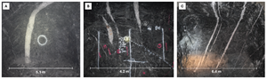
Typical auriferous quartz veining observed at Björkdal. (A) Main Zone. (B) Lake Zone. (C) Lake Zone Above.
Figure 4
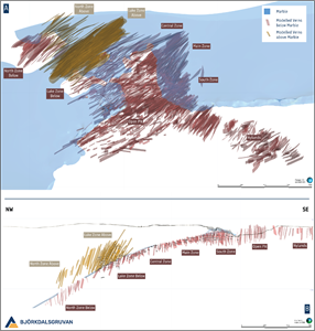
(A) Oblique view looking down and to the NE (Mine Grid) displaying known auriferous quartz veining at Björkdal. (B) Cross section ± 30 metres along the Björkdal deposit looking to the NE (Mine Grid).
Figure 5
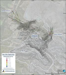
Mine Scale overview showing the location of the most recent drilling in relation to current underground development (Mine Grid).
Figure 6
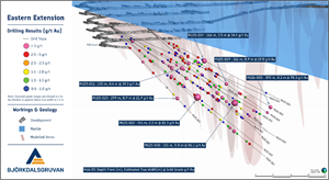
Oblique view to the WSW highlighting results from the most recent drilling campaign along the eastern flank of the underground mine.
Figure 7
Core tray photograph from MU25-030, where the highest-grade interval of the drill program was intersected.
Figure 8
Oblique view to the SW highlighting results from the most recent drilling campaign in the Northern extension of the underground mine.
Figure 9
Drill core photos from MU25-027 showing an intercept grading 25.2 g/t gold over 0.60 m (ETW 0.42 m) (A) and a close-up of mineralised quartz vein (B).
Alkane Resources Limited
Alkane Resources Limited
Legal Disclaimer:
EIN Presswire provides this news content "as is" without warranty of any kind. We do not accept any responsibility or liability for the accuracy, content, images, videos, licenses, completeness, legality, or reliability of the information contained in this article. If you have any complaints or copyright issues related to this article, kindly contact the author above.
